
Structure and Process - Influence of Historical Agriculture of Linear Flow Paths by Extreme Rainfall in Brandenburg
DOI:
https://doi.org/10.3097/LO.201231Keywords:
Erosion-3d, Historical land use, Model, Morphology, Rainstorm, Ridge and furrow system, Rusle, Water erosionAbstract
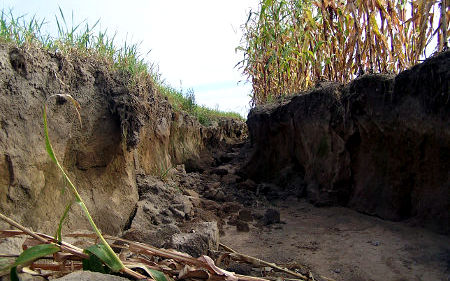
Long-term erosion forecast can completely misinterpret in extreme events in plain regions. Flow paths are well represented in the plain using digital elevation models in the 1-m grid (DEM1). The scale of the erosion process models and the elevation models is comparable. With it instruments are available to improve the erosion simulation. Simulations, based on (R)USLE family and bigger grid width, are relevant for regional overviews, to the clarification of small scale relevant linear erosion forms, however, unsuitably. The cross-slope tillage has intensified the water erosion in the examined case with special area morphology. From historical sources furrows of the ridge and furrow system were identified as runoff ways. Historical and actual information sources allowed the clarification of especially regional erosion events. Site specific and climatic factors as well as the actual land management caused a high damage magnitude in particular with extreme rainstorms, modified by historical land use structures.
References
Auerswald, K. (1993). Bodeneigenschaften und bodenerosion - wirkungswege bei unterschiedlichen Betrachtungsmaßstäben. Relief Boden Paläoklima,
Auerswald, K. (1992). Verfeinerte bewertung von Erosionsschutzmaßnahmen unter deutschen anbaubedingungen mit dem P-faktor der allgemeinen bodenabtragsgleichung (ABAG). Z. f. kulturtechnik und landentwicklung, verl. paul parey. Berlin u.Hamburg, 33, 137-144.
Barsch, D., Schukraft, G. A., & Schulte, A. (1998). Der eintrag von bodenerosionsprodukten in die gewässer und seine reduzierung - das geländeexperiment "langenzell". Bodenerosion - Analyse Und Bilanz Eines Umweltproblems, , 194-203.
Behrendt, H., & Dannowski, R. (2005). Nutrients and Heavy Metals in the Odra River System,
Behrendt, H., Huber, P., Ley, M., Opitz, D., Schmoll, O., Scholz, G., & Uebe, R. (1999). Nährstoffbilanzierung der flussgebiete deutschlands. Nährstoffbilanzierung Der Flussgebiete Deutschlands,
Boden, A. G. (2005). Bodenkundliche kartieranleitung. Bodenkundliche Kartieranleitung.5,
Böhm, C., Kiesel, J., Deumlich, D., & Thiere, J. (2009). An approach to extrapolate categorical agricultural soil data to nonmapped areas using majority vote. Journal of Plant Nutrition and Soil Science, 172(4), 467-476. doi:10.1002/jpln.200700057
Bork, H. -., Bork, H., Dalchow, C., Faust, B., Piorr, H. -., & Schatz, T. (1998). Landschaftsentwicklung in mitteleuropa. Landschaftsentwicklung in Mitteleuropa,
Bork, H. R., Dalchow, C., Frielinghaus, M., Frielinghaus, M., & Bork, H. R. (1999). Bodenentwicklung, bodenzerstörung und schutzbedürftigkeit von böden in der vergangenheit. Schutz Des Bodens.Umweltschutz—Grundlagen Und Praxis 4, , 16-28.
De Bakker, H., & Marsman, B. A. (1981). ( Cresty fields: Fields with an elevated centre and lower margins). [Kruinige percelen.] Boor En Spade, 20, 9-38.
DENECKE, D. (1979). Zur terminologie ur- und frühgeschichtlicher flurparzellierungen und flurbegrenzungen sowie im gelände ausgeprägter flurrelikte, grundzüge eines terminologischen schemas. Untersuchungen Zur Eisenzeitlichen Und Frühmittelalterlichen Flur in Mitteleuropa Und Ihrer Nutzung I, , 410-440.
Deumlich, D. (2012).
Deumlich, D. (1999). Erosive rainstorms and their probability in northeast germany. [Erosive Niederschläge und ihre Eintrittswahrscheinlichkeit im Nordosten Deutschlands] Meteorologische Zeitschrift, 8(5), 155-161. doi:10.1127/metz/8/1999/155
Deumlich, D., & Gödicke, K. (1989). Untersuchungen zu schwellenwerten erosionsauslösender niederschläge im jungmorä nengebiet der DDR. Arch.Acker-Pflanzenb.Bodenkd., 33(11), 709-716.
Domsch, H., & Giebel, A. (2004). Estimation of soil textural features from soil electrical conductivity recorded using the EM38. Precision Agriculture, 5(4), 389-409. doi:10.1023/B:PRAG.0000040807.18932.80
Duttman, R., Bach, M., & Herzog, A. (2011). Bodenerosion Durch Wasser, , 4.
Fenton, E. W. (1951). Vegetation and agricultural activities as shown by aerial photographs. Scottish Geographical Magazine, 67(2), 105-109. doi:10.1080/00369225108735481
Flanagan, D. C., & Nearing, M. A. (1995). USDA-water erosion prediction project: Hillslope profile and watershed model documentation. NSERL Report no.10,
Fohrer, N., Mollenhauer, K., & Scholten, T. (2003). Bodenerosion in: Nationalatlas Bundesrepublik Deutschland, , 106-109.
Frede, H. -., Bach, M., Fohrer, N., & Breuer, L. (2002). Interdisciplinary modeling and the significance of soil functions. Journal of Plant Nutrition and Soil Science, 165(4), 460-467. doi:10.1002/1522-2624(200208)165:4<460::AID-JPLN460>3.0.CO;2-B
Frielinghaus, M. (2002). Beiträge zum bodenschutz in mecklenburg-vorpommern. Bodenerosion, 2002, 82.
Frielinghaus, M., Winnige, B., Deumlich, D., & Kretzschmar, R. (2004). Schutz vor wassererosion. Handbuch Des Bodenschutzes.3rd Edn., , 684-695.
Haider, J. (1995). Prognose Von Bodenerosion Workshop,
Hard, G. (1970). Exzessive bodenerosion um und nach 1800. Erdkunde, 24, 290-308.
Hempel, L. (1954). Flurzerstörung und bodenerosion in früheren jahrhunderten. Ztschr.f.Agrargeschichte Und Agrarsoziologie, 2, 114-122.
Hierold, W., & Nagel, D. (2000). Die Wölbäcker Von Natteheide (Brandenburg)-Zeugnisse Historischer Landnutzung, , 101-111.
Hiller, D. (2007). Bodenerosion Durch Wasser, , 37.
Jankuhn, H. (1979). Vorwort, , 5-7.
Janssen, W. (1979). Altfluren Am Mittel- Und Niederrhein, , 338-375.
Katzur, L., & Wedel, H. (2010). Landesflug digitales geländemodell. Vermessung Brandenburg.Potsdam, 15(1), 53-62.
Kirkby, M. J., Jones, R. J. A., Irvine, B., Gobin, A., Govers, G., Cerdan, O., . . . Huting, J. (2004). Pan-european soil erosion risk assessment: The PESERA map, version 1 october 2003. European Soil Bureau Research Report no.16,
Krumbiegel, D., & Schwinge, W. (1991). Witterung-Klima Mecklenburg-Vorpommern, Brandenburg, Berlin,
Kuhnert, M. (2009). Quantification of Surface Runoff and Soil Erosion on Water Repellent Soils,
Kuo, W. -., Steenhuis, T. S., McCulloch, C. E., Mohler, C. L., Weinstein, D. A., DeGloria, S. D., & Swaney, D. P. (1999). Effect of grid size on runoff and soil moisture for a variable-source-area hydrology model. Water Resources Research, 35(11), 3419-3428. doi:10.1029/1999WR900183
Lück, E., Eisenreich, M., & Domsch, H. (0000). 2002.Innovative Kartiermethoden Für Die Teilflächenspezifische Landwirtschaft.,
Lück, E., Eisenreich, M., Domsch, H., & Blumenstein, O. (0000). Geophysik für landwirtschaft und bodenkunde. 2000.Geophysik Für Landwirtschaft Und Bodenkunde.,
Malitz, G. (2007). Analyse Der Hydrometeorologischen Verhältnisse in Bezug Auf Das Auftreten Von Starkniederschlag Am Pfingstwochenende 2007 Und an Weiteren Tagen Des Jahres 2007 Im Raum Brielow,
McNeill, J. D. (1980). Electromagnetic Terrain Conductivity Measurement at Low Induction Numbers,
Michael, A., Schmidt, J., & Schmidt, W. (1996). Band II Parameterkatalog Sachsen, Anwendung,
Montgomery, D. R. (2010). Dreck: Warum Unsere Zivilisation Den Boden Unter Den Füßen Verliert,
Nitzsche, O., Krück, S., Zimmerling, B., & Schmidt, W. (2002). Boden- und gewässerschonende landbewirtschaftung in flusseinzugsgebieten. Schriftenreihe Der Sächsischen Landesanstalt Für Landwirtschaft, 11, 1-22.
Notebaert, B., Verstraeten, G., Ward, P., Renssen, H., & Van Rompaey, A. (2011). Modeling the sensitivity of sediment and water runoff dynamics to holocene climate and land use changes at the catchment scale. Geomorphology, 126(1-2), 18-31. doi:10.1016/j.geomorph.2010.08.016
Pimentel, D., & Kounang, N. (1998). Ecology of soil erosion in ecosystems. Ecosystems, 1(5), 416-426. doi:10.1007/s100219900035
Renard, K. G., Foster, G. R., Weesies, G. A., McCool, D. K., & Yoder, D. C. (1997). Predicting Soil Erosion by Water: A Guide to Conservation Planning with the Revised Universal Soil Loss Equation (RUSLE),
Schmidt, J. (1996). Entwicklung und anwendung eines physikalisch begründeten simulationsmodells für dic erosion geneigter, landwirtschaftlicher nutzflächen. Berliner Geographische Abhandlungen,
Schmidt, J., Werner, M., & Michael, A. (1996).
Schwertmann, U., Vogl, W., & Kainz, M. (1990).
Voß, J., Schwan, A., Heyne, W., & Müller, N. (2010).
Weigl, E. (2007).
Werner, M. (1995).
Werner, M. (2005).
Werner, M. (2010).
Wischmeier, W. H. (1976). Use and misuse of the universal soil loss equation. Journal of Soil and Water Conservation, 31(1), 5-9.
Wischmeier, W. H., & Smith, D. D. (1978). Predicting Rainfall Erosion Losses: A Guide to Conservation Planning,
Wulf, M. (2020). Kulturlandschaftsforschung in brandenburg. November 2000 in Göttingen, 9, 87-100.
Downloads
Published
How to Cite
Issue
Section
License
Copyright (c) 2019 Detlef Deumlich

This work is licensed under a Creative Commons Attribution 4.0 International License.