Detecting land use and land cover changes in Northern German agricultural landscapes to assess ecosystem service dynamics
DOI:
https://doi.org/10.3097/LO.201435Keywords:
Agricultural management practice, Crop rotation, Provisioning services, Quantification, Remote sensingAbstract
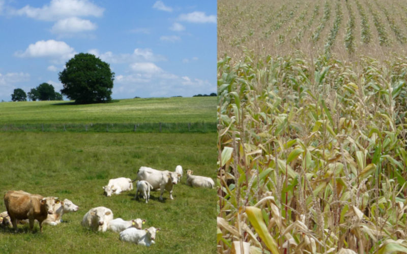
Land use and land cover (LULC) and their changes in share and number of classes can be documented by remote sensing techniques. Information on LULC is needed for the assessment of ecosystem services and is used as input data for mapping and modelling. This information is important for decision-making and management of ecosystems and landscapes. In this study, LULC were analysed in two agricultural areas in Northern Germany by means of a pixel-based maximum likelihood classification approach of 11 Landsat TM 5 scenes between 1987 and 2011 followed by a post-classification refinement using the tool IRSeL. In this time period, grassland declined by about 50 % in both case study areas. This loss in grassland area can be associated with changes in provisioning ecosystem services as the supply of fodder and crops and the number of livestock declined from 1987 to 2007. Furthermore, an on-going increase in maize cultivation area, which is nowadays more and more used as biomass for biogas production, documents the addition of another provisioning service, i.e., biomass for energy. Combining remote sensing and research on ecosystem services supports the assessment and monitoring of ecosystem services on different temporal, spatial, and semantic scales.
References
Blaschke, T. (2010). Object based image analysis for remote sensing. ISPRS Journal of Photogrammetry and Remote Sensing, 65(1), 2-16. doi:10.1016/j.isprsjprs.2009.06.004
Boyd, D. S., & Foody, G. M. (2011). An overview of recent remote sensing and GIS based research in ecological informatics. Ecological Informatics, 6(1), 25-36. doi:10.1016/j.ecoinf.2010.07.007
Brown, T. C., Bergstrom, J. C., & Loomis, J. B. (2007). Defining, valuing, and providing ecosystem goods and services. Natural Resources Journal, 47(2), 329-376.
Campbell, J. B. (1987). Introduction to remote sensing. Introduction to Remote Sensing,
Chander, G., Markham, B. L., & Helder, D. L. (2009). Summary of current radiometric calibration coefficients for landsat MSS, TM, ETM+, and EO-1 ALI sensors. Remote Sensing of Environment, 113(5), 893-903. doi:10.1016/j.rse.2009.01.007
Cohen, W. B., & Goward, S. N. (2004). Landsat's role in ecological applications of remote sensing. Bioscience, 54(6), 535-545. doi:10.1641/0006-3568(2004)054[0535:LRIEAO]2.0.CO;2
Congalton, R. G. (1991). A review of assessing the accuracy of classifications of remotely sensed data. Remote Sensing of Environment, 37(1), 35-46. doi:10.1016/0034-4257(91)90048-B
Crossman, N. D., Burkhard, B., & Nedkov, S. (2012). Quantifying and mapping ecosystem services. International Journal of Biodiversity Science, Ecosystem Services and Management, 8(1-2), 1-4. doi:10.1080/21513732.2012.695229
Dale, V. H., & Polasky, S. (2007). Measures of the effects of agricultural practices on ecosystem services. Ecological Economics, 64(2), 286-296. doi:10.1016/j.ecolecon.2007.05.009
de Groot, R. S., Alkemade, R., Braat, L., Hein, L., & Willemen, L. (2010). Challenges in integrating the concept of ecosystem services and values in landscape planning, management and decision making. Ecological Complexity, 7(3), 260-272. doi:10.1016/j.ecocom.2009.10.006
de Vries, S. C., van de Ven, G. W. J., van Ittersum, M. K., & Giller, K. E. (2010). Resource use efficiency and environmental performance of nine major biofuel crops, processed by first-generation conversion techniques. Biomass and Bioenergy, 34(5), 588-601. doi:10.1016/j.biombioe.2010.01.001
Estoque, R. C., & Murayama, Y. (2012). Examining the potential impact of land use/cover changes on the ecosystem services of baguio city, the philippines: A scenario-based analysis. Applied Geography, 35(1-2), 316-326. doi:10.1016/j.apgeog.2012.08.006
Fischbock, A., & Venebrügge, G. (1990). Bevölkerung, erwerbsstruktur und wandel der flächennutzung im hauptforschungsraum bornhöveder seenkette. Interne Mittelungen, Heft, 4, 233-235.
Fohrer, N., & Schmalz, B. (2012). The UNESCO ecohydrology demonstration site kielstau catchment - sustainable water resources management and education in rural areas. [Das UNESCO Ökohydrologie-Referenzprojekt Kielstau-Einzugsgebiet - Nachhaltiges Wasserressourcenmanagement und Ausbildung im ländlichen Raum] Hydrologie Und Wasserbewirtschaftung, 56(4), 160-168. doi:10.5675/HyWa_2012,4_1
Foody, G. (2008). Harshness in image classification accuracy assessment. International Journal of Remote Sensing, 29(11), 3137-3158. doi:10.1080/01431160701442120
Foody, G. M. (2002). Status of land cover classification accuracy assessment. Remote Sensing of Environment, 80(1), 185-201. doi:10.1016/S0034-4257(01)00295-4
Franke, J., Keuck, V., & Siegert, F. (2012). Assessment of grassland use intensity by remote sensing to support conservation schemes. Journal for Nature Conservation, 20(3), 125-134. doi:10.1016/j.jnc.2012.02.001
Fränzle, O., Kappen, L., Blume, H. -., & Dierssen, K. (2008). Ecosystem organization of a complex landscape - long-term research in the bornhöved lake district, germany. Ecosystem Organization of a Complex Landscape - Long-Term Research in the Bornhöved Lake District, Germany,
Haines-Young, R., & Potschin, M. (2010). Proposal for a common international classification of ecosystem goods and services (CICES) for integrated environmental and economic accounting. Proposal for a Common International Classification of Ecosystem Goods and Services (CICES) for Integrated Environmental and Economic Accounting,
Hirschberg, K., & Hirschberg, L. (0000).
Kandziora, M., Burkhard, B., & Müller, F. (2013). Interactions of ecosystem properties, ecosystem integrity and ecosystem service indicators: A theoretical matrix exercise. Ecological Indicators, 28, 54-78. doi:10.1016/j.ecolind.2012.09.006
Kandziora, M., Burkhard, B., & Müller, F. (2013). Mapping provisioning ecosystem services at the local scale using data of varying spatial and temporal resolution. Ecosystem Services, 4, 47-59. doi:10.1016/j.ecoser.2013.04.001
Kennedy, R. E., Townsend, P. A., Gross, J. E., Cohen, W. B., Bolstad, P., Wang, Y. Q., & Adams, P. (2009). Remote sensing change detection tools for natural resource managers: Understanding concepts and tradeoffs in the design of landscape monitoring projects. Remote Sensing of Environment, 113(7), 1382-1396. doi:10.1016/j.rse.2008.07.018
Kiesel, J., Schmalz, B., & Fohrer, N. (2009). SEPAL - A simple GIS-based tool to estimate sediment pathways in lowland catchments. Advances in Geosciences, 21, 25-32. doi:10.5194/adgeo-21-25-2009
Koschke, L., Fürst, C., Lorenz, M., Witt, A., Frank, S., & Makeschin, F. (2013). The integration of crop rotation and tillage practices in the assessment of ecosystem services provision at the regional scale. Ecological Indicators, 32, 157-171. doi:10.1016/j.ecolind.2013.03.008
Kroll, F., Müller, F., Haase, D., & Fohrer, N. (2012). Rural-urban gradient analysis of ecosystem services supply and demand dynamics. Land use Policy, 29(3), 521-535. doi:10.1016/j.landusepol.2011.07.008
Lautenbach, S., Kugel, C., Lausch, A., & Seppelt, R. (2011). Analysis of historic changes in regional ecosystem service provisioning using land use data. Ecological Indicators, 11(2), 676-687. doi:10.1016/j.ecolind.2010.09.007
Leh, M. D. K., Matlock, M. D., Cummings, E. C., & Nalley, L. L. (2013). Quantifying and mapping multiple ecosystem services change in west africa. Agriculture, Ecosystems and Environment, 165, 6-18. doi:10.1016/j.agee.2012.12.001
Lorencová, E., Frélichová, J., Nelson, E., & Vačkář, D. (2013). Past and future impacts of land use and climate change on agricultural ecosystem services in the czech republic. Land use Policy, 33, 183-194. doi:10.1016/j.landusepol.2012.12.012
Lorenz, M., Fürst, C., & Thiel, E. (2013). A methodological approach for deriving regional crop rotations as basis for the assessment of the impact of agricultural strategies using soil erosion as example. Journal of Environmental Management, 127, S37-S47. doi:10.1016/j.jenvman.2013.04.050
Meyer, M. (2000). Entwicklung Und Modellierung Von Planungsszenarien Für Die Landnutzung Im Gebiet Der Bornhöveder Seenkette,
Müller, F., Schrautzer, J., Reiche, E. -., & Rinker, A. (2006). Ecosystem based indicators in retrogressive successions of an agricultural landscape. Ecological Indicators, 6(1), 63-82. doi:10.1016/j.ecolind.2005.08.017
Oppelt, N., Rathjens, H., & Doernhoefer, K. (2012). Integration of land cover data into the open source model SWAT. Paper presented at the European Space Agency, (Special Publication) ESA SP, , 707 SP
Pax-Lenney, M., & Woodcock, C. E. (1997). Monitoring agricultural lands in egypt with multitemporal landsat TM imagery: How many images are needed? Remote Sensing of Environment, 59(3), 522-529. doi:10.1016/S0034-4257(96)00124-1
Polasky, S., Nelson, E., Pennington, D., & Johnson, K. A. (2011). The impact of land-use change on ecosystem services, biodiversity and returns to landowners: A case study in the state of minnesota. Environmental and Resource Economics, 48(2), 219-242. doi:10.1007/s10640-010-9407-0
Rathjens, H., Dörnhöfer, K., & Oppelt, N. (2014). IRSeL-an approach to enhance continuity and accuracy of remotelysensed land cover data. International Journal of Applied Earth Observation and Geoinformation, 31(1), 1-12. doi:10.1016/j.jag.2014.02.010
Rode, M. (2005). Energetische nutzung von biomasse und der naturschutz. Natur Und Landschaft, 80(9-10), 403-412.
Schleuß, U. (1992). Böden und bodenschaften einer norddeutschen moränenlandschatft: Ökologische eigenschaften, vergesellschaftung und funktion der böden im bereich der bornhöveder seenkette. Boden Und Bodenschaften Einer Norddeutschen.Moranenlandschaft.Okologische Eigenschaften, Vergesellschaftung Und Funktion Der Böden Im Bereich Der Bornhöveder Seenkette,
Schultze, C., & Köppel, J. (2007). Defined areas for the cultivation of energy crops? control options of planning. [Gebietskulissen für den Energiepflanzenanbau? Steuerungsmö glichkeiten der Planung] Naturschutz Und Landschaftsplanung, 39(9), 269-272.
Sexton, J. O., Urban, D. L., Donohue, M. J., & Song, C. (2013). Long-term land cover dynamics by multi-temporal classification across the landsat-5 record. Remote Sensing of Environment, 128, 246-258. doi:10.1016/j.rse.2012.10.010
Song, C., Woodcock, C. E., Seto, K. C., Lenney, M. P., & Macomber, S. A. (2001). Classification and change detection using landsat TM data: When and how to correct atmospheric effects? Remote Sensing of Environment, 75(2), 230-244. doi:10.1016/S0034-4257(00)00169-3
Steen, H. (2013). Daten zur biogasanlagen im kielstau-gebiete.
Wandhoff, V. (2013). Kiesgrube vierhusen.
Yuan, F., Sawaya, K. E., Loeffelholz, B. C., & Bauer, M. E. (2005). Land cover classification and change analysis of the twin cities (minnesota) metropolitan area by multitemporal landsat remote sensing. Remote Sensing of Environment, 98(2-3), 317-328. doi:10.1016/j.rse.2005.08.006
Downloads
Published
How to Cite
Issue
Section
Categories
License
Copyright (c) 2019 Marion Kandziora, Katja Dörnhöfer, Natascha M. Oppelt, Felix Müller

This work is licensed under a Creative Commons Attribution 4.0 International License.