Landscape Dynamics in Mediterranean Coastal Areas: Castelló de la Plana in the Last Hundred Years
DOI:
https://doi.org/10.3097/LO.201969Keywords:
Landscape Dynamics, Landscape Metrics, Cultural Landscape, UrbanisationAbstract
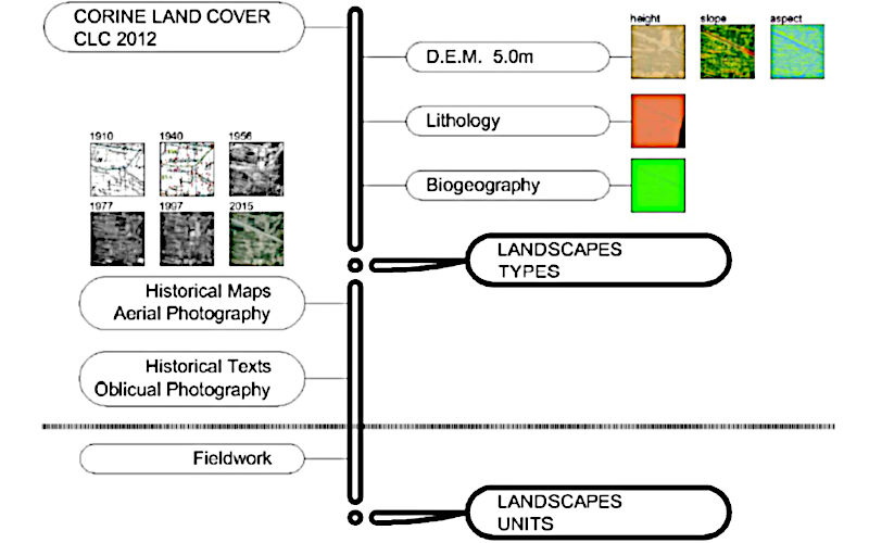
The littoral areas of the Mediterranean coastline have undergone a significant transformation due to their historical and intense human occupation. The result has been an evolution of different cultural landscape configurations, ranging from those with a marked agrarian character to artificial ones derived from the process of urbanisation and metropolitan growth. The objective of this paper is to define a model to characterise landscape types and units that explains the landscape dynamics (1910-2015) in Mediterranean coastal spaces at local scale, taking as study area the municipality and surroundings of Castelló de la Plana, in Spain. The aim is to identify the way in which society has appropriated and occupied this space. This research seeks to analyse landscape metrics that link dynamics in both space and time to provide a comprehensive image of landscape dynamics. The methodological procedure is based on the diachronic study of the landscape to discern a pattern of change in the cultural landscape over time and space that allows us to explain the current situation of the landscape and its relationship with urbanisation and urban planning.
References
Copernicus land monitoring service - urban atlas 2012. (2017). Copernicus Land Monitoring Service: Corine Land Cover,
Instituto nacional de estadística. (0000). Instituto Nacional De Estadística,
Quantum GIS geographic information system. (2014). Quantum GIS Geographic Information System,
Agnoletti, M. (2014). Rural landscape, nature conservation and culture: Some notes on research trends and management approaches from a (southern) european perspective. Landscape and Urban Planning, 126, 66-73. doi:10.1016/j.landurbplan.2014.02.012
Agnoletti, M., Conti, L., Frezza, L., & Santoro, A. (2015). Territorial analysis of the agricultural terraced landscapes of tuscany (italy): Preliminary results. Sustainability (Switzerland), 7(4), 4564-4581. doi:10.3390/su7044564
Aguilo, M. (2019). Guía para la elaboración de estudios del medio físico. ministerio de obras públicas y transportes. Guía Para La Elaboración De Estudios Del Medio Físico: Contenido y Metodología,
Amici, V., Maccherini, S., Santi, E., Torri, D., Vergari, F., & Del Monte, M. (2017). Long-term patterns of change in a vanishing cultural landscape: A GIS-based assessment. Ecological Informatics, 37, 38-51. doi:10.1016/j.ecoinf.2016.11.008
Antrop, M. (2000). Background concepts for integrated landscape analysis. Agriculture, Ecosystems and Environment, 77(1-2), 17-28. doi:10.1016/S0167-8809(99)00089-4
Antrop, M. (1997). The concept of traditional landscapes as a base for landscape evaluation and planning. the example of flanders region. Landscape and Urban Planning, 38(1-2), 105-117. doi:10.1016/S0169-2046(97)00027-3
Antrop, M. (2005). Why landscapes of the past are important for the future. Landscape and Urban Planning, 70(1-2), 21-34. doi:10.1016/j.landurbplan.2003.10.002
Benevolo, L. (1991). La Cattura Dell'Infinito,
Benoit, G., Coudert, E., & Moriconi-Ebrard, F. (2001). Urbanisation in the Mediterranean Region from 1950 to 1995,
Bürgi, M., Silbernagel, J., Wu, J., & Kienast, F. (2015). Linking ecosystem services with landscape history. Landscape Ecology, 30(1), 11-20. doi:10.1007/s10980-014-0102-3
Carvalho-Ribeiro, S., Ramos, I. L., Madeira, L., Barroso, F., Menezes, H., & Pinto Correia, T. (2013). Is land cover an important asset for addressing the subjective landscape dimensions? Land use Policy, 35, 50-60. doi:10.1016/j.landusepol.2013.04.015
Chias, P., & Abad, T. (2009). Geolocating and georeferencing: GIS tools for ancient maps visualisation. Paper presented at the Proceedings of the International Conference on Information Visualisation, 529-538. doi:10.1109/IV.2009.96
Costa, M. (1999). La Vegetación y El Paisaje En Las Tierras Valencianas,
García Martín, F. M., & Ros Sempere, M. (2016). Patterns of non-planned occupation of the peri-urban territory of the huerta de murcia, 1929-2015. In Back to the Sense of the City: International Monograph Book, , 826-837.
Giné, D. S. (2018). A renewed approach to the ABC landscape assessment method: An application to muntanyes d'ordal, barcelona metropolitan area. Landscape Online, 56, 1-13. doi:10.3097/LO.201856
Gómez-Zotano, J., Riesco-Chueca, P., Frolova, M., & Rodríguez-Rodríguez, J. (2018). The landscape taxonomic pyramid (LTP): A multi-scale classification adapted to spatial planning. Landscape Research, 43(7), 984-999. doi:10.1080/01426397.2017.1404021
Jaeger, J. A. G. (2000). Landscape division, splitting index, and effective mesh size: New measures of landscape fragmentation. Landscape Ecology, 15(2), 115-130. doi:10.1023/A:1008129329289
Jenny, B., & Hurni, L. (2011). Studying cartographic heritage: Analysis and visualization of geometric distortions. Computers and Graphics (Pergamon), 35(2), 402-411. doi:10.1016/j.cag.2011.01.005
Kohler, F., Marchand, G., & Negrão, M. (2015). Local history and landscape dynamics: A comparative study in rural brazil and rural france. Land use Policy, 43, 149-160. doi:10.1016/j.landusepol.2014.11.010
Kumar, M., Denis, D. M., Singh, S. K., Szabó, S., & Suryavanshi, S. (2018). Landscape metrics for assessment of land cover change and fragmentation of a heterogeneous watershed. Remote Sensing Applications: Society and Environment, 10, 224-233. doi:10.1016/j.rsase.2018.04.002
Lang, S., Walz, U., Klug, H., Blaschke, T., & Syrbe, R. -. (2008). Landscape metrics – a toolbox for assessing past, present and future landscape structures. Geoinformation technologies for geocultural landscapes: European perspectives (pp. 207-234)
López Martínez, F., Pérez Morales, A., & Gil Guirado, S. (2016). In landscape management all of us have something to say. A holistic method for landscape preservability evaluation in a mediterranean region. Land use Policy, 51, 172-183. doi:10.1016/j.landusepol.2015.11.004
Marcucci, D. J. (2000). Landscape history as a planning tool. Landscape and Urban Planning, 49(1-2), 67-81. doi:10.1016/S0169-2046(00)00054-2
McGarigal, K., Cushman, S. A., Neel, M. C., & Ene, E. (2002). FRAGSTATS: Spatial pattern analysis program for categorical maps. FRAGSTATS: Spatial Pattern Analysis Program for Categorical Maps,
Obiol Menero, E. M., & Soriano Martí, J. (2009). El sistema de riegos del millars y los cambios en el paisaje de la huerta de la plana. Los Regadíos Históricos Del Baix Millars-La Plana: Un Patrimonio Paisajístico En Transformación, , 27-38.
Ode, A., Tveit, M. S., & Fry, G. (2010). Advantages of using different data sources in assessment of landscape change and its effect on visual scale. Ecological Indicators, 10(1), 24-31. doi:10.1016/j.ecolind.2009.02.013
Olmo, R. M., & Muñoz, S. F. (2004). La huerta de murcia: Landscape guidelines for a peri-urban territory. Landscape Research, 29(4), 385-397. doi:10.1080/0142639042000289028
Palang, H., Spek, T., & Stenseke, M. (2011). Digging in the past: New conceptual models in landscape history and their relevance in peri-urban landscapes. Landscape and Urban Planning, 100(4), 344-346. doi:10.1016/j.landurbplan.2011.01.012
Plieninger, T., Draux, H., Fagerholm, N., Bieling, C., Bürgi, M., Kizos, T., . . . Verburg, P. H. (2016). The driving forces of landscape change in europe: A systematic review of the evidence. Land use Policy, 57, 204-214. doi:10.1016/j.landusepol.2016.04.040
Quereda Sala, J., Monton Chiva, E., & Escrig Barbera, J. (2010). Los recursos hídricos en el sistema hidrográfico del río mijares-la plana. Investigaciones Geográficas, 51, 185-202.
Rivas-Martínez, S., Penas, Á., Díaz, T. E., del Río, S., Cantó, P., Herrero, L., . . . Costa, J. C. (2014). Biogeography of spain and portugal. preliminary typological synopsis. International Journal of Geobotanical Research, 4(1), 1-64.
Sanjaume, E. (1985). Las costas valencianas. Sedimentología y Morfología,
Segado Vázquez, F., García Martín, A., & Rosique Campoy, M. (1996). Ordenación Del Territorio,
Smiraglia, D., Ceccarelli, T., Bajocco, S., Perini, L., & Salvati, L. (2015). Unraveling landscape complexity: Land Use/Land cover changes and landscape pattern dynamics (1954–2008) in contrasting peri-urban and agro-forest regions of northern italy. Environmental Management, 56(4), 916-932. doi:10.1007/s00267-015-0533-x
Statuto, D., Cillis, G., & Picuno, P. (2016). Analysis of the effects of agricultural land use change on rural environment and landscape through historical cartography and GIS tools. Journal of Agricultural Engineering, 47(1), 28-39. doi:10.4081/jae.2016.468
Stephenson, J. (2008). The cultural values model: An integrated approach to values in landscapes. Landscape and Urban Planning, 84(2), 127-139. doi:10.1016/j.landurbplan.2007.07.003
Tieskens, K. F., Schulp, C. J. E., Levers, C., Lieskovský, J., Kuemmerle, T., Plieninger, T., & Verburg, P. H. (2017). Characterizing european cultural landscapes: Accounting for structure, management intensity and value of agricultural and forest landscapes. Land use Policy, 62, 29-39. doi:10.1016/j.landusepol.2016.12.001
Tortora, A., Statuto, D., & Picuno, P. (2015). Rural landscape planning through spatial modelling and image processing of historical maps. Land use Policy, 42, 71-82. doi:10.1016/j.landusepol.2014.06.027
UNEP/MAP. (2016). Mediterranean strategy for sustainable development 2016–2025. Mediterranean Strategy for Sustainable Development 2016-2025,
Vega-Pozuleo, R., Torres-Márquez, M., & Naranjo-Ramírez, J. (2017). Recursos cartográficos y geohistóricos para el inventario de humedales temporales y desecados mediterráneos. GeoFocus, 19, 151-179.
Velázquez, A., & Bocco, G. (2001). Land unit approach for biodiversity mapping. Landscape Ecology Applied in Land Evaluation, Development and Conservation, , 273-286.
Wascher, D. M. (2005). European landscape character areas: Typologies, cartography and indicators for the assessment of sustainable landscapes. European Landscape Character Areas - Typologies, Cartography and Indicators for the Assessment of Sustainable Landscapes,
Zonneveld, I. S. (1989). The land unit - A fundamental concept in landscape ecology, and its applications. Landscape Ecology, 3(2), 67-86. doi:10.1007/BF00131171
Downloads
Published
How to Cite
Issue
Section
License
Copyright (c) 2019 Rafael Belda-Carrasco, Emilio Iranzo-García, Juan Antonio Pascual-Aguilar

This work is licensed under a Creative Commons Attribution 4.0 International License.