Rapid Assessment and Ground Truthing of Habitat Composition and Analysis of Semi-Natural Habitat Diversity of Proposed Greenway Developments
DOI:
https://doi.org/10.3097/LO.201977Keywords:
Greenways, Green Infrastructure, remote sensing, semi-natural habitat diversity, Google Street ViewAbstract
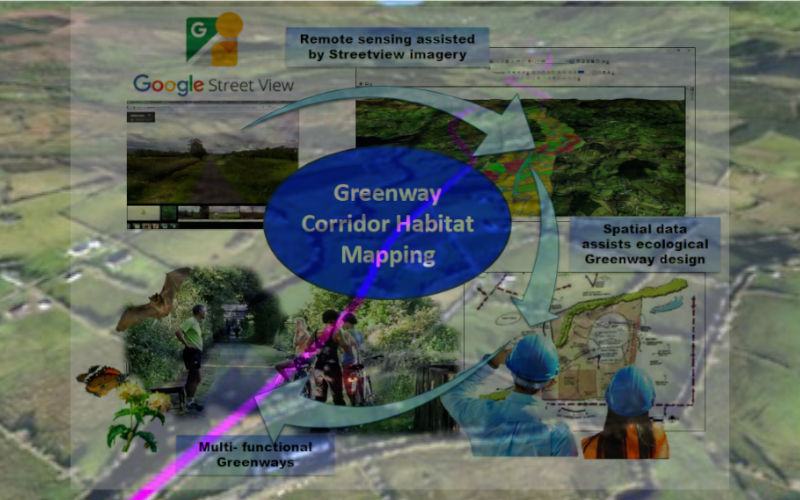
Across Europe, Greenways upcycle disused railway infrastructure into non-motorised public infrastructure, often with limited consideration to potential ecological synergies. Pre-development, disused transport corridors become relatively undisturbed and potentially host diverse semi-natural habitats. The study objectives were 1) to produce a highly detailed and accurate dataset using remote sensing with rapid assessment techniques for ground truthing and 2) subsequently examine habitat diversity existing along a proposed Greenway. A 7000 ha study corridor was based on a disused railway proposed as a transfrontier Greenway connecting the Republic of Ireland and the United Kingdom. The study applied a rapid-assessment virtual validation techniquealongside remote sensing and accuracy assessment. Inter-relationship between seminatural habitat diversity and land-use intensification was examined. Remote sensing accuracies of 89% and 99% for a real and linear habitat classification were obtained. Degrees of land-use intensification were observed throughout the corridor, highlighting the importance of maintaining and enhancing remaining semi-natural habitat that exists along the proposed Greenway route. Through understanding the landscape matrix composition and semi-natural habitat diversity, European Greenwayscan achieve multi-functionality for ecosystem conservation, forming integral components of Green Infrastructure.
References
Ahern, J. 2013. Urban landscape sustainability and resilience: the promise and challenges of integrating ecology with urban planning and design. Landscape Ecology 28 (6), 1203- 1212. DOI:10.1007/s10980-012-9799-z DOI: https://doi.org/10.1007/s10980-012-9799-z
Anderson, J.R. 1971. Land use classification schemes used in selected recent geographic applications of remote sensing. Photogrammetric Engineering 37 (4), 379–387. DOI:10.3133/pp964 DOI: https://doi.org/10.3133/pp964
Barr, C. J.; Bunce, R. G. H.; Clarke, R. T.; Fuller, R. M.; Furse, M. T.; Gillespie, M. K.; Groom, G. B.; Hallam,C. J.; Hornung, M.; Howard, D. C. & Ness, M. J. 1993. Countryside Survey 1990. Main Report. London: Department of the Environment.
Baudry, J.; Bunce, R. G. H. & Burel, F. 2000. Hedgerows: An international perspective on their origin, function and management. Journal of Environmental Management 60 (1), 7-22. DOI:10.1006/jema.2000.0358 DOI: https://doi.org/10.1006/jema.2000.0358
Berland, A. & Lange, D. A. 2017. Google Street View shows promise for virtual street tree surveys. Urban Forestry & Urban Greening 21, 11-15. DOI:10.1016/j.ufug.2016.11.006 DOI: https://doi.org/10.1016/j.ufug.2016.11.006
Billeter, R.; Liira, J.; Bailey, S.; Bugter, R.; Arens, P.; Augenstein, I.; Aviron, S; Baudry, J.; Bukacek, R.; Burel, F.; Cerny, M.; De Blust, G.; De Cock, R.; Diek¨otter, T.; Dietz, H.; Dirksen, J.; Dormann, C.; Durka, W.; Frenzel, M.; Hamersky, R.; Hendrickx, F.; Herzog, F.; Klotz, S.; Koolstra, B.; Lausch, A.; Le Coeur, D.; Maelfait, J.; Opdam, P.; Roubalova, M.; Schermann, A.; Schermann, N.; Schmidt, T.; Schweiger, O.; Smulders, M.; Speelmans, M.; Simova, P.; Verboom, J.; van Wingerden, W.; Zobel, M. & Edwards, P. 2008. Indicators for biodiversityin agricultural landscapes: a pan- European study. Applied Ecology 45(1), 141–150. DOI:10.1111/j.1365-2664.2007.01393.x DOI: https://doi.org/10.1111/j.1365-2664.2007.01393.x
Bischoff, N. T. & Jongman, R. H. G. 1993. Development of rural areas in Europe: The claim for nature. Netherlands Scientific Council for Government Policy preliminary and background studies V79. Sdu Publishers, The Hague, The Netherlands.
Bommarco, R. 2013. Ecological intensification: harnessing ecosystem services for food security. Trends in Ecology & Evolution 28 (4), 230-238. DOI:10.1016/j.tree.2012.10.012 DOI: https://doi.org/10.1016/j.tree.2012.10.012
Bullock, J. M.; Jefferson, R. G.; Blackstock, T. H.; Pakeman, R. J.; Emett, B. A.; Pywell, R. J.; Grime, P.& Silvertown, J. 2011 Semi-natural Grasslands In: The UK National Ecosystem Assessment Technical Report. UK National Ecosystem Assessment, UNEP-WCMC, Cambridge.
Burel, F.; Baudry, J.; Butet, A.; Clergeau, P.; Delettre, Y. & Le Coeur, D. 1998. Comparative biodiversity along a gradient of agricultural landscapes. Acta Oecologica 19, 47-60.DOI:10.1016/s1146- 609x(98)80007-6 DOI: https://doi.org/10.1016/S1146-609X(98)80007-6
Carlier,J.&Moran, J.2018.SLNCRProposedGreenway Route: 1km wide Habitats Interpretation Map. Mendeley Data, v1 DOI:10.17632/xpdmwcz2sj.1
Carlier, J. & Moran, J. 2019a. Landscape typology and ecological connectivity assessment to inform Greenway design. Science of the Total Environment 651: 3241-3252. DOI:10.1016/j.scitotenv.2018.10.077 DOI: https://doi.org/10.1016/j.scitotenv.2018.10.077
Carlier, J. & Moran, J. 2019b. Hedgerow typology and condition analysis to inform greenway design in rural landscapes. Journal of Environmental Management 247, 790 - 803. DOI:10.1016/j. jenvman.2019.06.116 DOI: https://doi.org/10.1016/j.jenvman.2019.06.116
Carlier, J.; Moran, J.; Aughney, T.; Roche, N. 2019. Effects of greenway development on functional connectivity for bats. Global Ecology and Conservation 18, e00613. DOI:10.1016/j.gecco.2019.e00613 DOI: https://doi.org/10.1016/j.gecco.2019.e00613
Chenoweth, J.; Anderson A. R.; Kumar, P.; Hunt, W. F.; Chimbwandira, S. J.& Moore, T. L. C. 2018. The interrelationship of green infrastructure and natural capital. Land Use Policy 75, 137-144. DOI:10.1016/j.landusepol.2018.03.021 DOI: https://doi.org/10.1016/j.landusepol.2018.03.021
Donald P. F. & Evans A. D. 2006. Habitat connectivity and the matrix restoration: the wider implications of agri-environmental schemes. Journal of Applied Ecology 43, 209-218. DOI:10.1111/j.1365- 2664.2006.01146.x DOI: https://doi.org/10.1111/j.1365-2664.2006.01146.x
Erickson, D. L; Lovell, S. T. & Mendez, V. E. 2013. Identifying, quantifyingandclassifyingagricultural opportunities for land use planning. Landscape and Urban Planning 118, 29–39. DOI:10.1016/j. landurbplan.2013.05.004 DOI: https://doi.org/10.1016/j.landurbplan.2013.05.004
ESRI 2014. ESRI ArcGIS Desktop: Release 10.2.2. Estreguil, C.; Caudullo, G.; Rega, C. & Paracchini, M.L. 2016. Enhancing Connectivity Improving Green Infrastructure: Cost-benefit solutions for forest and agri-environment. A pilot study in Lombardy.
CICES. 2017. Structure of CICES. https://cices.eu/ JRC Science for Policy Report, European (Date: 23.08.2018) Commission.
Comber, A.; Fisher, P.; Brundson, C. & Khmag, A. 2012. Spatial analysis of remote sensing image classification accuracy. Remote Sensing of Environment 127, 237–246. DOI:10.1016/j. rse.2012.09.005 DOI: https://doi.org/10.1016/j.rse.2012.09.005
Commission of the European Communities 2001. Presidency Conclusions: Göteborg European Council 15 and 16 June 2001.
Congalton, R. G. 1991. A Review of Assessing the Accuracy of Classifications of Remotely Sensed Data. Remote Sensing of Environment 37, 35-46. DOI:10.1016/0034-4257(91)90048-B DOI: https://doi.org/10.1016/0034-4257(91)90048-B
Congalton, R. G. & Green, K. 2008. Assessing the accuracy of remotely sensed data: principles and practices. CRC press. DOI:10.1201/9780429052729 DOI: https://doi.org/10.1201/9781420055139
Croxton, P. J.; Hann, J. P.; Greatorex-Davies, J. N. & Sparks, T.H. 2005. Linear hotspots? The floral and butterfly diversity of green lanes. Biological Conservation 121, 579–584. DOI:10.1016/j. biocon.2004.06.008 DOI: https://doi.org/10.1016/j.biocon.2004.06.008
European Commission 1999. European Spatial Development Perspective. Potsdam, European Commission.
European Commission 2011. Our Life Insurance, Our Natural Capital: an EU Biodiversity Strategy to 2020. Brussels.
European Commission 2013. Green infrastructure (GI) – Enhancing Europe’s Natural Capital. Brussels.
European Commission 2015. Report from the Commission to the European Parliament and the Council ‘The mid-term review of the EU Biodiversity Strategy to 2020’ (COM (2015) 0478 final).
European Environment Agency 2006. The thematic accuracy of Corine land cover 2000 - Assessment using LUCAS. Technical report No. 7/2006
European Environment Agency 2011. Landscape Fragmentation in Europe. Luxembourg, Publications Office.
European Environment Agency 2016. Urban Sprawl in Europe. Luxembourg, Publications Office.
European Greenways Association 1998. The European Greenways Good Practice Guide. Namur: European Greenways Association.
Fabos, J. G. 1995. Introduction and overview: the greenway movement, uses and potentials of greenways. Landscape and Urban Planning 33, 1-13. DOI:10.1016/j.landurbplan.2004.09.028 DOI: https://doi.org/10.1016/0169-2046(95)02035-R
Faiers, A. & Bailey, A. 2005. Evaluating canalside hedgerows to determine future interventions. Journal of Environmental Management 74 (1), 71–78. DOI:10.1016/j.jenvman.2004.08.009 DOI: https://doi.org/10.1016/j.jenvman.2004.08.009
Fealy, R. M.; Green, S.; Loftus, M.; Meehan, R.; Radford, T.; Cronin, C. & Bulfin, M. 2009. Teagasc EPA Soil and Subsoils Mapping Project-Final Report. Volume I. Teagasc: Dublin.
Foody, G. M. 2002. Status of land cover classification accuracy assessment. Remote Sensing of Environment 80 (1), pp. 185-201. DOI:10.1016/ S0034-4257(01)00295-4 DOI: https://doi.org/10.1016/S0034-4257(01)00295-4
Fossitt, J. A. 2000. A Guide to Habitats in Ireland. The Heritage Council, Kilkenny, Ireland.
Foulkes, N.; Fuller, J.; Little, D.; McCourt, S. & Murphy, P. 2013. Hedgerow Appraisal System - Best Practise Guidance on Hedgerow Survey, Data Collation and Appraisal. Woodlands of Ireland, Dublin. Unpublished Report.
Fumagalli, N. & Toccolini, A. 2012. Relationship between Greenways and Ecological Network: A Case Study in Italy. Department of Agricultural Engineering, University of Milan. DOI:10.22059/ ijer.2012.561
García-Feced, C.; Weissteiner, C. J.; Baraldi, A.; Paracchini, M. L.; Maes, J.; Zulian, G.; Kempen, M.; Elbersen B. & Pérez-Soba, M. 2015. Semi-natural vegetation in agricultural land: European map and links to ecosystem service supply. Agronomy for Sustainable Development 35 (1), 273–283. DOI:10.1007/s13593-014-0238-1 DOI: https://doi.org/10.1007/s13593-014-0238-1
Geological Survey of Ireland. 2004. Breifne. https:// www.gsi.ie/Education/Sites+Walks+Field+Trips/ Breifne.htm (Date: 03.09.2016).
Google 2018. Google Street View. https://www. google.ie/maps/Street View/ (Date 1.11.2015).
Jongman, R. H. G. 2003. Ecological networks and greenways in Europe: Reasonings and Concepts. Journal of Environmental Sciences 15 (2): 173-181.
Jongman, R. & Pungetti, G. 2004. Ecological Networks and Greenways: Concept, Design, Implementation. Cambridge: University of Cambridge. DOI:10.1017/CBO9780511606762 DOI: https://doi.org/10.1017/CBO9780511606762
Keith, S. J.; Larson, L. R.; Shafer, C. S.; Hallo, J. C. & Fernandez, M. 2018. Greenway use and preferences in diverse urban communities: Implications for trail design and management. Landscape and Urban Planning 172, 47- 59. DOI:10.1016/j.landurbplan.2017.12.007 DOI: https://doi.org/10.1016/j.landurbplan.2017.12.007
Landis, J. R. & Koch, G. G. 1977. The measurement of observer agreement for categorical data. Biometrics 33: 159–174. DOI:10.2307/2529310 DOI: https://doi.org/10.2307/2529310
Larson, L. R.; Keith, S. J.; Fernandez, M.; Hallo, J. C.; Shafer, S. C. & Jennings, V. 2016. Ecosystem services and urban greenways: what’s the public’s perspective? Ecosystem Services 22, 111-116. DOI:10.1016/j.ecoser.2016.10.004 DOI: https://doi.org/10.1016/j.ecoser.2016.10.004
McCune, B. & Mefford, M. J. 2016. PC-ORD. Multivariate Analysis of Ecological Data. Version 7. MjM Software, Gleneden Beach, Oregon, U.S.A.
McGarrigle, M. 2014. Assessment of small water bodies in Ireland. Biology and Environment: Proceedings of the Royal Irish Academy, 114B(3) Small Water Bodies: Importance, Threats and Knowledge Gaps: 119-128. DOI:10.3318/ bioe.2014.15 DOI: https://doi.org/10.3318/bioe.2014.15
Minogue, R. 2002. Landscape Assessment of County Leitrim. Environmental Resources Management, Dublin.
Morelli, F.; Beim, M.; Jerzak, L.; Jones, D. & Tryjanowski, P. 2014. Can roads, railways and related structures have positive effects on birds? A review. Transportation Research Part D: Transport and Environment 30, 21-31. DOI:10.1016/j.trd.2014.05.006 DOI: https://doi.org/10.1016/j.trd.2014.05.006
Morton, D.; Rowland, C.; Wood, C.; Meek, L.; Marston, C.; Smith, G.; Wadsworth, R. & Simpson, I. C. 2011. Final Report for LCM2007 - the new UK Land Cover Map. Centre for Ecology & Hydrology, Natural Environment Research Council.
Nagendra, H. 2002. Opposite trends in response for the Shannon and Simpson indices of landscape diversity. Applied Geography 22, 175-186. DOI:10.1016/S0143-6228(02)00002-4 DOI: https://doi.org/10.1016/S0143-6228(02)00002-4
O’Sullivan, O. S.; Holt, A. R.; Warren, P. H. & Evans, K. L. 2017. Optimising UK urban road verge contributions to biodiversity and ecosystem services with cost-effective management. Journal of Environmental Management 191, 162-171. DOI:10.1016/j.jenvman.2016.12.062 DOI: https://doi.org/10.1016/j.jenvman.2016.12.062
Rollett, A.; Haines-Young, R.; Potschin, M. & Kumar, P. 2008. Delivering environmental services through agri-environment programmes: a scoping study. Report Num: EO0300011 - FC 73-03-03-54.
Ryan, R. L.; Fabos, J. G. & Allan, J. J. 2004. Understanding opportunities and challenges for collaborative greenway planning in New England. Landscape and Urban Planning 76: 172–191. DOI: https://doi.org/10.1016/j.landurbplan.2004.09.031
Saunders, D. A.; Hobbs, R. J. & Margules, C. R. 1991. Biological consequences of ecosystem fragmentation:Areview.ConservationBiology5,(1) 18-32. DOI:10.1016/j.landurbplan.2004.09.031 DOI: https://doi.org/10.1111/j.1523-1739.1991.tb00384.x
Secretariat of the Convention on Biological Diversity. 2014. Global Biodiversity Outlook 4, Montréal.
Sheridan, H.; McMahon, B. J.; Carnus, T.; Finn, J. A.; Anderson, A.; Helden, A. J.; Kinsella, A. & Purvis, G. 2011. Pastoral farmland habitat diversity in south-east Ireland. Agriculture, Ecosystems and Environment 144, 130–135.DOI:10.1016/j. agee.2011.07.011 DOI: https://doi.org/10.1016/j.agee.2011.07.011
Smith, F.; O‘Donoghue, P.; O‘Hora, K. & Delaney, E. 2011. Best Practice Guidance for Habitat Survey and Mapping. The Heritage Council, Kilkenny, Ireland.
Smits, P. C.; Dellepiane, S. G. & Schowengertd, R. A. 1999. Quality assessment of image classification algorithms for land-cover mapping: a review and a proposal for a cost-based approach. International Journal of Remote Sensing 20 (8): 1461- 1486. DOI:10.1080/014311699212560 DOI: https://doi.org/10.1080/014311699212560
Stehman, S. V. 1996 Estimating the Kappa Coefficient and its Variance under Stratified Random Sampling. Photogrammetric Engineering & Remote Sensing 62 (4): 401- 407.
Stehman, S. V. 2000.Practical Implications of Design-Based Sampling Inference for Thematic Map Accuracy Assessment. Remote Sensing of Environment 72 (1), pp. 35-45. DOI:10.1016/ S0034-4257(99)00090-5 DOI: https://doi.org/10.1016/S0034-4257(99)00090-5
Sullivan, C. A.; Finn, J. A.; Ó hÚallacháin, D. O.; Green, S.; Matin, S.; Meredtith, D.; Clifford, B. & Moran, J. 2017. The development of a national typology for High Nature Value farmland in Ireland based on farm-scale characteristics. Land Use Policy 67, 401-414. DOI:10.1016/j.landusepol.2017.04.031 DOI: https://doi.org/10.1016/j.landusepol.2017.04.031
Thomlinson, J. R.; Bolstad, P. V. & Cohen, W. B. 1999. Coordinating methodologies for scaling landcover classifications from site-specific to global: steps toward validating global map products. Remote Sensing of Environment 70, 16– 28.10.1016/ S0034-4257(99)00055-3 DOI: https://doi.org/10.1016/S0034-4257(99)00055-3
Tscharntke, T.; Klein, A. M.; Kruess, A.; Steffan- Dewenter, I. & Thies, C. 2005. Landscape perspectives on agricultural intensification and biodiversity—ecosystem service management. Ecology Letters 8, 857–874. DOI:10.1111/j.1461- 0248.2005.00782.x DOI: https://doi.org/10.1111/j.1461-0248.2005.00782.x
Toccolini, A.; Fumagalli, N. & Senes, G. 2006. Greenways planning in Italy: the Lambro River Valley Greenways System. Landscape and Urban Planning 76, 98–111. DOI:10.1016/j. landurbplan.2004.09.038 DOI: https://doi.org/10.1016/j.landurbplan.2004.09.038
Vandevelde, J. C.; Bouhours, A.; Julien, J.-F.; Couvet, D. & Kerbiriou, C. 2014. Activity of European common bats along railway verges. Ecological Engineering 64: 49–56. DOI:10.1016/j. ecoleng.2013.12.025 DOI: https://doi.org/10.1016/j.ecoleng.2013.12.025
Verhoeve, A.; Dewaelheynsa, D.; Kerselaersa, E.; Roggea, E. B. & Gulinckc, H. 2015. Virtual farmland: Grasping the occupation of agricultural land by non-agricultural land uses. Land Use Policy 42: 547–556. DOI:10.1016/j.landusepol.2014.09.008 DOI: https://doi.org/10.1016/j.landusepol.2014.09.008
Vogiatzakis,I.N.;Mannion,A.M.&Griffiths,G.H.2006. Mediterranean Ecosystems: problems and tools for conservation. Progress in Physical Geography 30: 175–200. DOI:10.1191/0309133306pp472ra DOI: https://doi.org/10.1191/0309133306pp472ra
Walker, M. P.; Dover, J. W.; Hinsley, S. A. & Sparks, T. H. 2005. Birds and green lanes: Breeding season bird abundance, territories and species richness. Biological Conservation 126: 540–547. DOI:10.1016/j.biocon.2005.07.005 DOI: https://doi.org/10.1016/j.biocon.2005.07.005
Walsh, S. 2012. A Summary of Climate Averages 1981-2010 for Ireland, Climatological Note No.14, Met Éireann, Dublin.
Downloads
Published
How to Cite
Issue
Section
License
Copyright (c) 2019 Julien Carlier, James Moran

This work is licensed under a Creative Commons Attribution 4.0 International License.