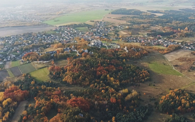
How has the landscape changed? Landscape transformation analysis of Ogrodzieniec-Podzamcze (POLAND) using landgraphy and landscape stratigraphy methods.
DOI:
https://doi.org/10.3097/LO.2023.1110Keywords:
cultural landscape, landscape stratigraphy, landscape changes, landscape visualizationAbstract
This article presents a combination of landscape biography and stratigraphy as a method for the visualisation of historical landscape change. The main goal was to analyse the evolution of the cultural landscape of part of the Ogrodzieniec municipality – Podzamcze (Częstochowa Upland, Poland). The evolution of the landscape was reconstructed based on cartographic materials (topographic maps from the last 200 years) and scholarly literature. The results show the dominance of the agricultural landscape in all studied periods. The forest and settlement landscapes expanded significantly within the studied period. The fortified landscape is clearly visible as a core running through all the years. The results indicate changes of an evolutionary type and heterogenous (genetically), heterotonic (in terms of land cover) form. The method can be used in well-documented areas to visualise the past and contemporary landscapes and to forecast future ones, so it can be useful in landscape planning.
References
Affek, A. 2012. Kalibracja map historycznych z zastosowaniem GIS. Georeferencing of historical maps using GIS. Dissertations of Cultural Landscape Commission, 16, 48–62.
Aldred, O., Fairclough, G. 2003. Historic Landscape Characterisation: taking stock of the method. London: English Heritage/Somerset County Council.
Antrop, M. 2004. Landscape change and the urbanization process in Europe. Landscape and urban planning, 67(1-4), 9-26. https://doi.org/10.1016/S0169-2046(03)00026-4 DOI: https://doi.org/10.1016/S0169-2046(03)00026-4
Błaszczyk W. 1965. Zamki Jury Krakowsko-Wieluńskiej. Wydawnictwo: Wojewódzki Komitet Kultury Fizycznej i Turystyki w Katowicach.
Bogdanowski, J., Łuczyńska-Bruzda, M., Novak, Z. 1979. Architektura krajobrazu. Landscape architecture. PWN, Warszawa
Chmielewski, T.J. 2012. Systemy Krajobrazowe. Struktura, Funkcjonowanie, Planowanie. Landscape Systems. Structure, Functioning, Planning. Wydawnictwo Naukowe PWN: Warszawa, Poland,
Chmielewski, T.J., Myga-Piątek, U., Solon, J. 2016. Typologia aktualnych krajobrazów Polski. Typology of Poland’s current landscapes. Przegląd Geograficzny, 87(3), 377-408. DOI: https://doi.org/10.7163/PrzG.2015.3.0
Cygankiewicz, I. 2011. Problem rozproszenia zabudowy w krajobrazie wiejskim, na przykładzie gminy Ogrodzieniec. The problem of scattered buildings in rural landscape, the example of Ogrodzieniec commune. Przestrzeń i Forma, 15, 323-334.
Cygankiewicz, I., Łaś, J. 2021. Tendencies in Settlement Planning in Light of the Idea of a Village in a Park Space’in the Ogrodzieniec Municipality. Przestrzeń i Forma, 48, 129- 148. DOI: https://doi.org/10.21005/pif.2021.48.C-03
Darvill, T. 2006. Stonehenge. The biography of a landscape. Stroud: Tempus Publishing
Database of Topographic Object, 2014 and 2020, 1:10 000. https://mapy.geoportal.gov.pl [access: 10.05.2021].
Database of Topographic Object, V Map Level 2, 2007, 1:50 000. https://mapy.geoportal.gov.pl [access: 10.05.2021]
Fairclough, G. 2010. Landscape and Spatial Planning in England: past achievements, present questions, future goals. Planowanie i zagospodarowanie przestrzenne jako instrument kształtowania krajobrazów kulturowych, 125- 140.
Foltyn, E., Waga J.M. 1992. Przyczynek do badań epoki kamienia i epoki brązu okolic Kroczyc. A contribution to the study of the Stone Age and Bronze Age in the vicinity of Kroczyce. I Sympozjum Jurajskie, ZJPK, Dąbrowa Górnicza, 99-109.
Ginter, B. 1966. Powierzchniowe badania archeologiczne przeprowadzone w północnej części Jury Krakowsko- Częstochowskiej. Surface archaeological investigations carried out in the northern part of the Jura Krakowsko- Częstochowska. Zeszyty naukowe Śląskiego Uniwersytetu Naukowego, 13.
Godłowski K., Kozłowski J.K. 1985. Historia starożytna ziem polskich, PWN, Warszawa
Godłowska M., Kozłowski J.K., Kruk J., Lech J., Rook E. 1995. Młodsza epoka kamienia, w: Pradzieje i średniowiecze, Natura i kultura w krajobrazie Jury, Kraków, 49-85.
Godłowski K. 1995. Okres lateński i rzymski 1995: w: Pradzieje i średniowiecze, Natura i kultura w krajobrazie Jury, Kraków, 113-137.
Green, P.F., Lidmar-Bergström, K., Japsen, P., Bonow, J.M., Chalmers, J.A. 2013. Stratigraphic landscape analysis, thermochronology and the episodic development of elevated, passive continental margins. Geological Survey of Denmark & Greenland Bulletin, 30. DOI: https://doi.org/10.34194/geusb.v30.4673
Górski, U.J. 1993. Zamek Ogrodzieniecki w Podzamczu i okolica, Sosnowiec.
Jaworek, J. 2012. Ocena historycznych cech krajobrazu jako podstawa dla ich ochrony w gospodarowaniu i planowaniu. Assessment of historic landscape features as a basis for their protection in management and planning. Czasopismo Techniczne, 29(7-A), 57-66.
Kołodziej-Pawłowska, B. 2010. Ogrodzieniec : miasto i gmina. Urząd Miasta i Gminy,
Kondracki, J. 1998. Geografia Regionalna Polski. Regional Geography of Poland. Wydawnictwo Naukowe PWN: Warszawa, Poland,
Kruk J., Przywara L., 1983: Roślinność potencjalna jako metoda rekonstrukcji naturalnych warunków rozwoju społeczności pradziejowych. W: Archeologia Polski, T. 28, Wydawnictwo PWN, Warszawa, 19-50.
Kuna, J. 2015. Metodyczne aspekty analiz przestrzennych GIS wykorzystujących dawne mapy topograficzne. Methodological aspects of GIS spatial analyses with early topographic maps. Dawne mapy topograficzne w badaniach geograficzno-historycznych, 125-149.
Lieskovský, J., Bürgi,M. 2018.Persistenceinculturallandscapes: a pan-European analysis. Regional Environmental Change 18, 175–187. https://doi.org/10.1007/s10113-017-1192-7 DOI: https://doi.org/10.1007/s10113-017-1192-7
Marcucci, D.J. 2000. Landscape history as a planning tool. Landscape and urban planning, 49(1-2), 67-81. https://doi.org/10.1016/S0169-2046(00)00054-2 DOI: https://doi.org/10.1016/S0169-2046(00)00054-2
Marks, L. 2016. Zmiany klimatu w holocenie. Przegląd Geologiczny. vol. 64, 1, 59-6.
Młodkowska-Przepiórowska I. 1995. Kultura przeworska na ziemi częstochowskiej. Muzeum Częstochowskie, Częstochowa.
Muzolf, B. 1994. Późnorzymska osada kultury przeworskiej w miejscowości Podzamcze, gmina Ogrodzieniec, woj. katowickie, [in:] J. Gurba, A. Kokowski (eds.), Kultura przeworska, 1, Lublin.
Myga-Piątek, U. 2012: Krajobrazy kulturowe. Aspekty ewolucyjne i typologiczne. Cultural landscapes. Evolutionary and typological aspects. Uniwersytet Śląski.
Myga-Piątek, U. 2018. Model stratygrafii krajobrazów kulturowych. W poszukiwaniu typologii ewolucyjno- genetycznej. Stratigraphic Model of Cultural Landscapes – in Search for Evolutionary-Genetic Typology. Dissertations of Cultural Landscape Commission, 39(1) 2018, 207–223. https://doi.org/10.30450/201812.
Nalepka D., Walanus A. 2003: Data processing in pollen analysis. Acta Palaeobotanica 43(1): 125-134.
National Digital Archive, photo signature: 1-U- 4451, https://audiovis.nac.gov.pl/obraz/120821/ec0ed3ef1df15fa4892679325e517095/, [access: 08.04.2020],
Nita, J., Myga-Piątek, U. 2012. Krajobrazowe skutki wzrostu powierzchni leśnych na Wyżynie Częstochowskiej. Landscape consequences the growth of forests of the Czestochowa Upland. Dissertations of Cultural Landscape Commission, 16, 191-207.
Nita, J., Myga-Piątek U. 2018. Mikroregiony i submikroregiony Wyżyny Częstochowskiej na tle podziału fizycznogeograficznego Wyżyny Śląsko-Krakowskiej. Micro- regions and submicro-regions of the Częstochowa Upland at the background of physico-geographical subdivision of the Silesian-Cracow Upland. Prace Geograficzne, 266, 211- 224.
Partyka, J. (Ed.). 2004. Zróżnicowanie i przemiany środowiska przyrodniczo-kulturowego Wyżyny Krakowsko- Częstochowskiej. Ojcowski Park Narodowy.
Raszeja, E. 2015. Ochrona krajobrazu w procesie przekształceń obszarów wiejskich. Landscape protection in rural transformation. Wydawnictwo Uniwersytetu Przyrodniczego w Poznaniu.
Roymans, N., Gerritsen, F., Van der Heijden, C., Bosma, K., Kolen, J. 2009. Landscape biography as researchstrategy: The case of the South Netherlands project. Landscape research, 34(3), 337-359. DOI: 10.1080/01426390802381185 DOI: https://doi.org/10.1080/01426390802381185
Rydzewski, J. 1995: Epoka brązu i wczesna epoka żelaza, w: Pradzieje i średniowiecze, Natura i kultura w krajobrazie Jury, Kraków, 93-113.
Strzelecki, W. 1951. Zamek w Ogrodzieńcu. Ogrodzieniec Castle. Ochrona Zabytków, (3-4), 133-149.
Poleski, M. 1919. Zamek Ogrodzieniecki na tle najbliższej okolicy. Jego przeszłość i stan obecny. Ogrodzieniecki Castle against the background of the immediate area. Its past and current state. Warszawa.
Richling, A., Solon, J., Macias, A., Balon, J., Borzyszkowski, J., Kistowski, M. 2021. Regionalna geografia fizyczna Polski. Regional physical geography of Poland. Bogucki Wydawnictwo Naukowe.
Sulimierski, F., Chlebowski, B., Walewski, W. 1886. Słownik geograficzny Królestwa Polskiego i innych krajów słowiańskich (Vol. 7). Warszawa.
Sobala, M. 2012. Zastosowanie austriackich map katastralnych w badaniach użytkowania ziemi w połowie XIX wieku. The use of Austrian cadastral maps in land use studies in the mid-nineteenth century, Polski Przegląd Kartograficzny, 44(4), 324-333.
Solon, J., Borzyszkowski, J., Bidłasik, M., Richling, A., Badora, K., Balon, J., Brzezińska-Wójcik, T., Chabudziński, Ł., Dobrowolski, R., Grzegorczyk, I., et al. 2018. Physico-geographical mesoregions of Poland: Verification and adjustment of boundaries on the basis of contemporary spatial data. Geographia Polonica, 91, 143–170. https://doi.org/10.7163/GPol.0115 DOI: https://doi.org/10.7163/GPol.0115
Topographic map 1944, 1965, 1:50 000. https://mapy.geoportal.gov.pl [access: 10.05.2021].
Topographic map of the Kingdom of Poland, 1831, 1:126 000. https://bg.uwb.edu.pl [access: 10.05.2021].
Urbisz, A. 2008. Różnorodność i rozmieszczenie roślin naczyniowych jako podstawa regionalizacji geobotanicznej Wyżyny Krakowsko-Częstochowskiej. Katowice: Wydawnictwo Uniwersytetu Śląskiego.
Turner, S. (2018). Historic landscape characterisation: an archaeological approach to landscape heritage. Routledge handbook of landscape character assessment, 37-50. https://doi.org/10.4324/9781315753423-3 DOI: https://doi.org/10.4324/9781315753423-3
Żemła-Siesicka, A., Myga-Piątek, U. 2021a. A Landscape Persistence Assessment of Częstochowa Upland: A Case Study of Ogrodzieniec, Poland. Sustainability, 13(11), 6408. https://doi.org/10.3390/su13116408 DOI: https://doi.org/10.3390/su13116408
Żemła-Siesicka, A., Myga-Piątek, U. 2021b. Methods and tools in landscape persistence imaging with the example of a stratigraphy model, GIS Odyssey Journal, 1(1). https://doi.org/10.57599/gisoj.2021.1.1.5
Żemła-Siesicka, A. 2022. Archaeological landscape–the past and the present. A case study of the megalithic landscape of Wietrzychowice, Poland. Landscape Online, 1099-1099. https://doi.org/10.3097/LO.2022.1099 DOI: https://doi.org/10.3097/LO.2022.1099
Downloads
Published
How to Cite
Issue
Section
License
Copyright (c) 2023 Urszula Myga-Piątek, Anna Żemła-Siesicka

This work is licensed under a Creative Commons Attribution 4.0 International License.